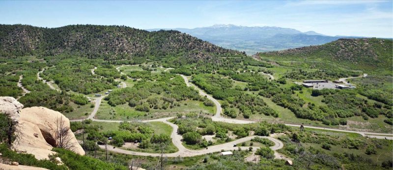
Photos: Aramark · courtesy of National Park Service. Click a photo to enlarge.
Morefield Campground
Overview
Morefield Campground is four miles from the park entrance. The 267 campsites are situated within a high-elevation, grassy canyon filled with Gambel oak, native flowers, deer, and wild turkeys. Each site has a picnic table, gravel tent pad, and fire pit/BBQ grill.
- Operator
- National Park
- Camping types
- Tent, RV
- Sites
- 267 campsites
- Fee
- From $38 per night (confirm with the operator)
- Reservations
- Reservable online
- Phone
- 18004492288
Amenities
Location
Nearby adventures
Hikes and trailheads
- Prater Ridge TrailheadShow on map
- Point Lookout TrailheadShow on map
- Phil's World Trailhead
The Phil's World Trail system is part of the Cortez Special Recreation Management Area (SRMA) with an emphasis on non-motorized trail opportunities. OpenStreetMap
Show on map - Visit Mesa Verde's Historic Administrative District
Take a walk amid the early park structures that comprise the Historic Administrative District of Mesa Verde National Park. National Park Service
Show on map - Aspen Loop TrailShow on map
Scenic sights
- Mancos Overlook
A viewpoint on the park road in Mesa Verde National Park. AI-written
Show on map - Point Lookout
A viewpoint on the park road in Mesa Verde National Park. AI-written
Show on map - Menefee Peak
Menefee Peak is a mountain summit in the southern San Miguel Mountains range of the Rocky Mountains of North America. Wikipedia
Show on map - Roof Crack- climbing caveShow on map
- Ute Peak / Wisuv Káruv
Ute Mountain, also known as Ute Peak or Sleeping Ute Mountain, is a peak within the Ute Mountains, a small mountain range in the southwestern corner of Colorado. Wikipedia
Show on map
Climbing and snow sports
- Hesperus Ski Area
A small ski area west of Durango. AI-written
Show on map
Trail and sight data: OpenStreetMap contributors (ODbL) and National Park Service. Text marked Wikipedia is from Wikipedia under CC BY-SA 4.0, lightly shortened. Text marked AI-written was drafted by an AI model from public data and may contain errors.
Reviews
Data sources
Listing details come from the sources above and may be out of date. Confirm fees, dates and closures with the operator before you travel.